Toronto is about to get slammed by the ‘most impactful’ snow storm of the year

Environment Canada has issued a winter storm watch for the majority of southern Ontario and Toronto is expected to get hit with up to 20 cm of snow starting this Friday. According to The Weather Network, this ‘blizzard-like’ storm “could end up being the most impactful of the season so far.”
Toronto clearly can’t get a break.
Storm, after storm, after storm, the city has dealt with several winter events throughout the month of February -strong winds, heavy snow, and dangerous driving conditions.
It’s been a pretty active winter for much of the province but this anticipated winter storm takes the cake.
According to The Weather Network, due to a rapidly intensifying Texas low, heavy snow is set to begin Friday evening and last into the first half of Saturday.
And we could easily see the heaviest snowfall totals this season in some parts of southern Ontario – up to 30 cm of snow.
Recent Posts:
You can day trip from Toronto to Ontario’s maple festivals this month
Homes for sale in small Ontario towns that will make you want to leave the city
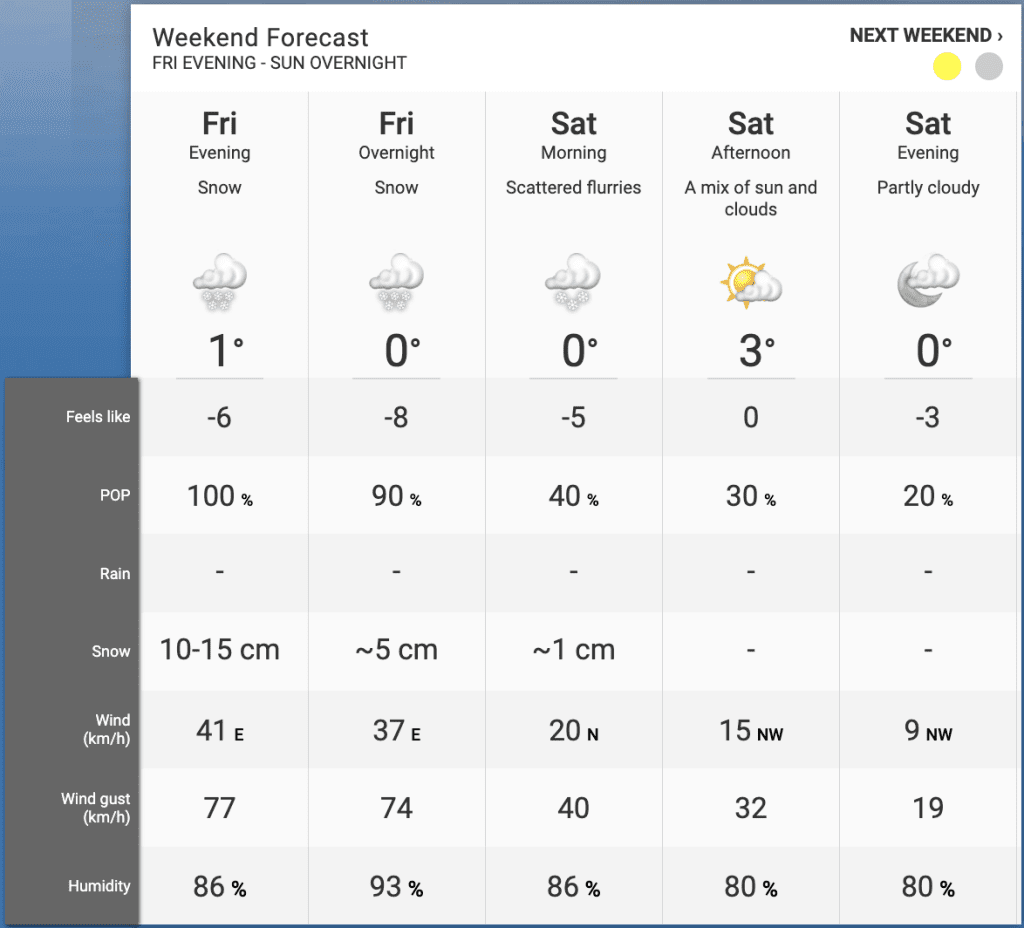
Strong winds, extensive blowing snow, and blizzard-like conditions are a huge threat, more so towards the west end of Lake Ontario, according to TWN.
Will Toronto see THAT much snow? Most likely not. Environment Canada is expected 15 cm to 20 cm of snowfall accumulations in the area and wind gusts of up to 77 km/h. It’s definitely something to be wary of.
“We’ll see a hefty blanket of snow fall from the GTA into eastern Ontario,” said TWN. “The heaviest accumulations will pile up where the heart of this band lingers the longest, while the potential for mixing could limit ultimate accumulations south of the GTA.”
And as always, travel could be difficult, especially on highways, roads, walkways, and parking lots as they may become icy and slippery.
It’s still unknown as to what parts of southern Ontario will face the worst of it – nonetheless you’ll want to stay indoors this Friday and reschedule your weekend plans.


