These Canadian provinces might be getting snow on the last days of summer

Yes, you read that right. A little bit of winter weather might be in store for two Canadian provinces early next week: Alberta and BC. It looks like we skipped right over fall in this forecast – and we’re certainly not ready.
While it isn’t the first time Albertans have experienced ‘summer snow’ this year, it will mark the first potential snowfall of the year for BC.
“Snow will arrive in the Yukon and Northwest Territories first, eventually spreading south into B.C. and Alberta by early next week,” according to The Weather Network.
Recent Posts:
You can sip on Pumpkin Spice Milk Tea at this popular bubble tea spot
Ice cream, coffee, & cocktails: You can take a tour of all the Nanaimo bar-inspired treats in BC
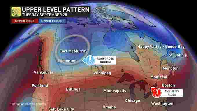
The forecast says that “a strong upper-level trough diving southward will put Western Canada next in line for snow,” bringing fall-like temperatures to BC and Alberta by the end of the weekend.
In terms of specifics, the forecast predicts daytime high temps in the mid to upper-teens in the northern and central parts of both provinces.
Will winter arrive early for much of Canada? ?❄ Find out now with our LIVE 2022 Fall #Aftercast!
Check out our complete #FallForecast here: https://t.co/b7XEL75syd https://t.co/VkzHsce1kl
— The Weather Network (@weathernetwork) September 13, 2022
Folks can expect chillier air to spill down from the Arctic as the trough makes its way further south, with a combo of cold and stormy weather patterns slated for much of Western Canada.
While most of the forecasted snowfall is likely to stick to higher elevations, forecasters claim that as cooler air creeps to lower elevations overnight, we could start to see some flakes in the foothills and closer to more communities.
And there you have it – a very bizarre sendoff for summer 2022. Might as well embrace it and start donning your cozy winter knits!


