Mix of rain & snow: Here's what Vancouver's weather forecast looks like this week

Well, Vancouver, we’re in for an interesting week of weather. According to a new report by The Weather Network, BC’s forecast is looking rainier and colder than usual, with possible “late-season snowflakes” set to appear at lower elevations. Though we doubt you’ll need your shovels, it might be a good time to bring out the warmer layers!
On Monday, April 17th and Tuesday, April 18th, snow levels are expected to drop below 1,000 metres after hovering between the 1,000-1,500 metre range. This means that some places may be on the receiving end of a mix of rain and snow, including the Simon Fraser University area and sections of Vancouver Island.
In terms of the Lower Mainland, residents can expect rainfall totals of 30 to 50 mm, according to the report.
Recent Posts:
Season 2 of ‘The Last of Us’ will be filmed in Vancouver & here’s what we know so far
Zellers is now open in BC & here’s where
If you’ve been hoping this week will be warmer and not rainy, B.C., we’re sorry. #BCstormhttps://t.co/FXQx5od2xU
— The Weather Network (@weathernetwork) April 16, 2023
As confirmed through the current 14-day forecast, Raincouver will be in full swing, with 5 to 20 mm of rain forecasted every day this week.
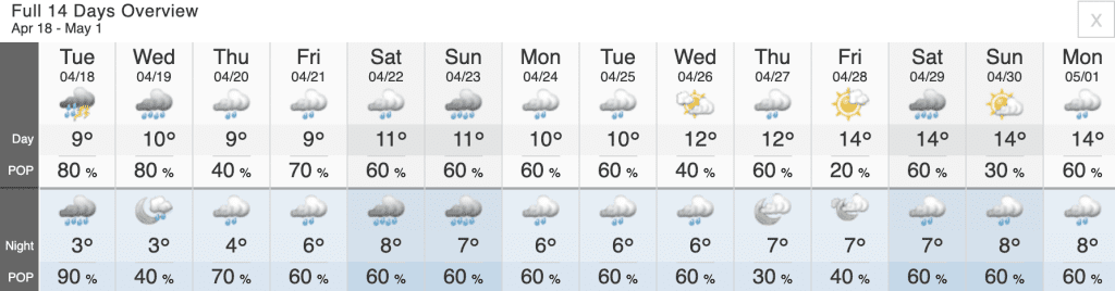
Overall, temperatures this April have been around 2 to 3 degrees below the seasonal average. However, things are slowly but surely warming up, with sun in the forecast starting Wednesday, April 26th. As well, Vancouverites can expect daytime highs of 14 degrees starting Friday, April 28th.
So there you have it, Vancouver. Not the best news for spring weather lovers, but not the worst! Once we’re through this week, things should be warming up significantly.
Until then, bundle up and stay safe!


